Mapping & Surveying
Aerial Mapping & Surveying
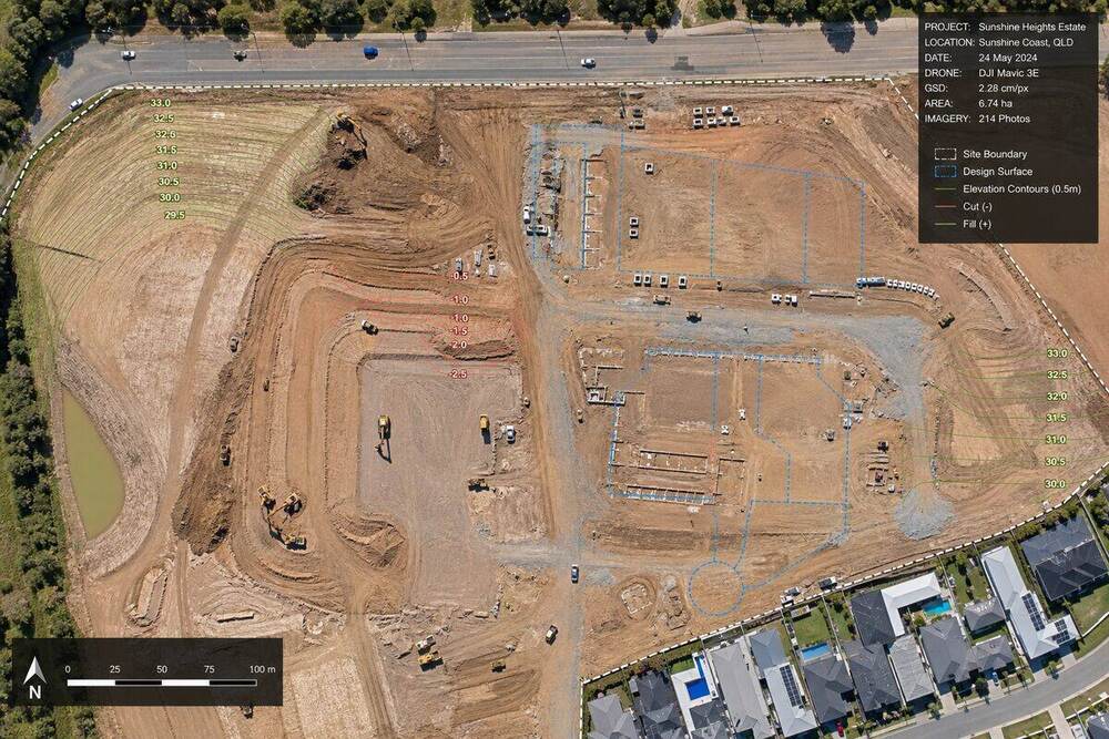
“Survey-grade orthomosaic mapping, photogrammetry, and 3D models.”
High-accuracy drone mapping for construction, mining, civil infrastructure, and land development. Orthomosaic, DSM, DEM, contours, volumes, and 3D textured mesh outputs to ±2cm vertical accuracy.
Overview
What you get when you engage Drone Inspect for mapping & surveying.
A drone equipped with RTK or PPK GNSS captures geo-referenced imagery accurate to ±2 cm horizontal and ±3 cm vertical. Processed through industry-standard photogrammetry software (Pix4D, DroneDeploy, Bentley ContextCapture) the result is a survey-grade orthomosaic, digital surface model, and 3D textured mesh delivered in your CAD coordinate system.
We work with civil contractors, mining operators, surveyors, and developers who need fast, accurate, repeatable spatial data without standing up a full survey crew. Stockpile volume reports turn around in 48 hours. Construction progress orthos refresh weekly. Earthworks cut/fill validation overlays directly into client design models.
For projects where spatial truth matters - and where every week of delay costs money - drone mapping outperforms traditional ground survey on speed, cost, and update frequency.
Capabilities
What is included in every mapping & surveying engagement.
RTK / PPK GNSS Capture
L1/L2 dual-frequency receivers with ground control points. Achieves ±2cm horizontal and ±3cm vertical accuracy traceable to AHD/MGA datum.
Orthomosaic Output
Geo-referenced GeoTIFF orthos at 1cm to 5cm GSD. Compatible with QGIS, ArcGIS, AutoCAD, Civil 3D, and 12d Model.
Digital Surface & Terrain Models
DSM and DEM outputs at user-specified resolution. Contour generation at 100mm intervals or finer for engineering use.
Stockpile Volume Reports
Volumetric calculations to ±1.5% accuracy. Compatible with mining, quarry, and construction earthworks reporting requirements.
3D Textured Mesh & Point Cloud
Photogrammetric 3D models in OBJ, FBX, and LAS/LAZ formats. Compatible with Bentley ContextCapture, Trimble Business Center, and Autodesk ReCap.
Cut/Fill & Earthworks Validation
Surface comparison between as-built capture and design model. Heatmap overlays show under-fill and over-cut zones at ±50mm accuracy.
FAQ
Common questions about mapping & surveying.
What survey accuracy can drone mapping actually achieve?
With RTK/PPK GNSS and well-distributed ground control points, photogrammetric accuracy is typically ±2cm horizontal and ±3cm vertical at 100m flight altitude. This matches Class B detail survey accuracy per AS 4187 and is suitable for stockpile volumetrics, earthworks design pickup, and most engineering as-built use cases. For higher accuracy (±10mm) or sub-canopy work, traditional total-station survey is still required.
How does drone mapping compare to traditional ground survey on cost?
For sites under 5 hectares, drone and ground survey are roughly cost-comparable. Above 10 hectares, drone is typically 40 to 70 percent cheaper per hectare while delivering significantly higher data density (millions of points vs hundreds). For repeat capture (weekly construction progress, monthly stockpile updates), drone is dramatically cheaper because mobilisation is a fraction of ground survey crew rates.
What output formats and software do you support?
Standard outputs: GeoTIFF orthomosaic, LAS/LAZ point cloud, OBJ/FBX 3D mesh, DXF contours, KML/KMZ. Compatible with QGIS, ArcGIS, AutoCAD Civil 3D, 12d Model, Bentley OpenRoads, Trimble Business Center, Pix4D, and DroneDeploy. Custom output formats and coordinate systems supported on request, including all Australian MGA zones and AHD datum transformations.
Get a mapping & surveying quote in 24 hours.
Send us the address and what you need to know. Fixed-price quote in writing within one business day.
Request Quote